The Adobe Acrobat Reader is required to
view documents presented in .pdf format. If .pdf documents
do not appear when you click on a link, you must download
and install the Acrobat Reader from the Adobe
web site.
|
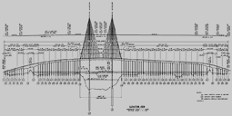
The
Plan and Elevation Diagram shows the entire
13,759-foot (4194m) system of bridges and
approaches. Click to see bridgeplan.pdf
(250k)
|
|
Bridge Plans
The diagram on this page was produced by designers
of the bridge and is included in a book of plans being
used by the contractor during construction.
- Pages in the original document are
11×17 inches. This page size is reproduced in the
.pdf document.
- Measurements are given in metric,
in accordance with Federal Highway Administration
(FHWA) standards at the time of design. (1 meter =
3.28 feet)
| The cable-stayed bridge
is located between piers 36 and 39. Click
to see bridgeplan.pdf (250k). |
|
Orientation: The Plan and Elevation diagram
provides an overview of the Greenville Bridge project.
The diagram shows the entire 13,759-foot (4194.96m)
system of structures including the bridge and its east
and west approaches. The structures will be supported
by 89 piers, which are individually numbered.
This diagram, as well as Phase 1 of the
construction project, deals only with activity between
piers 36 and 39: construction of the actual cable-stayed
bridge. The bridge approaches will be built in future
construction phases.
- Piers 1-35 support the bridge approach
on the Arkansas side
- Pier 36 is the western anchor pier
for the cable-stayed bridge
- Pier 37 provides a foundation for the
west bridge tower
- Pier 38 provides a foundation for the
east bridge tower
- Pier 39 is the eastern anchor pier
for the cable-stayed bridge
- Piers 40-89 support the bridge approach
on the Mississippi side.
|